Kamis, 17 Maret 2011

National Monument (Indonesia)

National Monument (Indonesia)


Monumen Nasional

Monumen Nasional
Type Obelisk Monument
Location Central Jakarta, Indonesia
Client Government of Indonesia
Owner Republic of Indonesia
Started 17 August 1961
Inaugurated 12 July 1975
Height 132m
Main contractor P.N. Adhi Karya
(foundation piles)
Architect Frederich Silaban,
R.M. Soedarsono
The National Monument (Indonesian: Monumen Nasional (Monas)) is a 433 ft (132 meter) tower in the center of Merdeka Square, Central Jakarta, symbolizing the fight for Indonesia's independence. Construction began in 1961 under the direction of President Sukarno and the monument was opened to the public in 1975. It is topped by a flame covered with gold foil. The monument and the museum is open daily from 08.00 - 15.00 Western Indonesia Time, everyday throughout the week, except for the last Monday of each month, when the monument is closed.

Background

Sukarno inspect Monas construction in 1963.
After the Indonesian government returned to Jakarta from Yogyakarta in 1950 following the Dutch recognition of Indonesian independence, President Sukarno began to contemplate the construction of a national monument comparable to the Eiffel Tower on the square in front of the Presidential Palace. On 17 August 1954, a National Monument Committee was established and a design competition was held in 1955. This attracted 51 entries, but only one design, by Frederich Silaban, met any of the criteria determined by the committee, which included reflecting the character of Indonesia in a building capable of lasting for centuries. A repeat competition was held in 1960, but once again, none of the 136 entries met the criteria. The chairman of the jury team then asked Silaban to show his design to Sukarno. However, Sukarno did not like the design as he wanted the monument to be in the form of a linga and yoni. Silaban was asked to design such a monument, but his design was for a monument so large that it would have been unaffordable given the economic conditions at the time. Silaban refused to design a smaller monument, suggesting that construction be delayed until the Indonesian economy improved. Sukarno then asked the architect R.M. Soedarsono to continue with the design. Soedarsono incorporated the numbers 17, 8 and 45, representing the 17 August 1945 Proclamation of Indonesian Independence, in the dimensions of the monument.[1][2][3]

Construction

Construction proceeded in three stages. The first period, from 1961/1962 – 1964/1965 began with the official start of construction on 17 August 1961 with Sukarno ceremonially driving in the first concrete pile. A total of 284 piles were used for the foundation block. A further 360 piles were driven in for the museum foundations, with work being completed in March 1962. The walls of the museum in the base were completed by October. Construction of the obelisk than commenced and was finished in August 1963. Work in the second stage, from 1966 to 1968 was delayed by shortages of funding and the aftermath of the 30 September Movement coup attempt. In the final phase, from 1969–1976, the dioramas for the historical museum were added. Problems remained once construction was complete, and work was needed to solve problems with water leaking into the museum. The monument was officially opened to the public on 12 July 1975.[4][5] The location of the construction site is known as Merdeka Square.

Monument design

"Monas" and the Jakarta skyline
The towering monument encapsulates the philosophy of Lingga and Yoni. Lingga resembles an alu rice pestle and Yoni resembles a lesung rice mortar, two important traditional Indonesian tools. Lingga and Yoni also symbolize eternal life with the lingga phallic symbol, representing masculinity, positive elements, and daytime and the Yoni the female organs symbol, representing femininity, negative elements, and night. The monument consists of a 117.7m obelisk on a 45m square platform at a height of 17m, the goblet yard. The obelisk itself is clad with Italian marble.[6][7]
The northern pond measuring 25×25 m was designed to cool water for the air conditioning system in the monument as well as to enhance the beauty of the surrounding area. To the north of the monument, there is a statue of Indonesia national hero Prince Diponegoro by Italian sculptor Cobertaldo.[8] The entrance to the monument is located at the Medan Merdeka Utara or Northern Merdeka Park, through the underground tunnel visitors will reach the northern side of the monument. The ticket office is located at the end of the tunnel. When visitors resurface in northern side of the monument, visitors could took a round trip outside the monument to see reliefs of Indonesian history; continued to National History Museum at the base on northeastern corner, or continued straight to the center of the monument towards Hall of Independence or elevator.

Reliefs of Indonesian History

High reliefs of Indonesian history depicting Gajah Mada and Majapahit history
On the outer yard encircling the monument, on each four corners, there are high reliefs of Indonesian History. The story begins in the northeastern corner, and describes the ancient glory of the Indonesian archipelago, featuring ancient history especially that of Singhasari and Majapahit. The relief continues to the southeast, southwest, and northwest corners, chronologically displaying European colonialization of the Indonesian archipelago, popular local uprisings, modern Indonesian organization in the early 20th century, the Japanese occupation in World War II, the Proclamation of Independence, the Indonesian National Revolution and post-independence develelopments. The reliefs and statues were made from molded cement, but several of these statues are already damaged and have decayed due to torrential rain and the tropical climate.

The National History Museum

Inside the base of the monument there is the Indonesian National History Museum, located three metres below the surface of the monument. It is a large marble-lined room measuring 80 x 80 metres with 48 dioramas along the walls side depicting scenes from the Indonesian history from prehistory until the New Order, plus 3 other dioramas in the center of the room, making a total of 51 dioramas. The dioramas begin at the northeast corner, and show the history of Indonesia; from prehistory, the era of ancient kingdoms such as Srivijaya and Majapahit, followed by European colonialization and local uprisings against the VOC and Dutch East Indies rule. The dioramas continue well into the 20th century, Japanese occupation, Indonesian independence proclamation in 1945, to the struggle for independence of Indonesian revolution, and on to the New Order era of Suharto's regime.

The Hall of Independence

Hall of Independence
Inside the goblet or "cup" part of the monument, there is the Hall of Independence (Indonesian: Ruang Kemerdekaan) shaped like an . The hall is accessible through spiral stairs at the north and south doors. It contains symbols of Indonesian independence and nationhood, including the original text of the Proclamation of Independence in a glass case, the coat of arms of Indonesia, and a map of the Indonesian archipelago in gold.[1][9]. The original text of Indonesian proclamation of independence is stored in a glass case inside the golden door on the west side of inner-wall clad in black marble. The mechanized bronze doors weigh 4 tons, and are coated with gold adorned with the image of awijaya kusuma flower, symbolizing eternity, and a lotus flower, symbolizing purity. The doors known as Gerbang Kemerdekaan or the Gate of Independence and are opened slowly using a mechanism while the nationalist Padamu Negeri song plays, followed by a recording of Sukarno reading the text of the Proclamation. On southern side wall there is a large statue of Garuda Pancasila, the coat of arms of Indonesia, made from 3.5 tons of bronze coated with gold. On eastern side there is the text of the proclamation in bronze lettering. Originally the eastern side displayed the most sacred Indonesian flag, Sang Saka Merah Putih, originally raised on 17 August 1945. However because it is fragile and in poor condition, it is no longer displayed. The northern side wall displays a map of the Indonesian archipelago coated in gold.

The Peak Platform Observation deck and Flame of Independence

The 115 meter-high platform where visitors can look out over central Jakarta
A lift on the southern side carries visitors to the 11 meter by 11 meter viewing platform, at a height of 115 meters. The capacity of the elevator is about 11 people. The top platform can accommodate about 50 people, and also provided with binoculars. There is also a staircase for use in emergencies. The total height of the monument is 132 meters. The distance from the viewing platform to the tip of the flame is 17 meters. The ticket to top platform is Rp.7,500 for adult at beginning of January 2011.
The monument is topped by a 14.5 ton bronze Flame of Independence containing the lift engine. The base of the flame where the elevator door is located is 3 meters high and is in the shape of a goblet. The bronze flame structure measures 14 meters in height and 6 meters in diameter, It consists of 77 sections bound together. Originally the bronze flame structure was covered with 35 kg[1] of gold foil, however during the 50th anniversary of Indonesian independence in 1995, the gold foil was recoated and increased to 50 kg[10] gold foil. The obelisk and flame symbolize the Indonesia people's struggle for independence. The middle platform on top of the cawan (goblet) provides visitor with views of the surroundings from a height of 17 meters. The goblet yard is accessible through elevator on the way down or through the stairs.

Senin, 14 Maret 2011

RMS Titanic

RMS Titanic

RMS Titanic 3.jpg
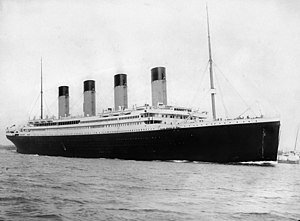
RMS Titanic departing Southampton on 10 April 1912.
Career ( United Kingdom) White Star flaga.svg White Star Line
Name: RMS Titanic[1]
Owner: White Star flaga.svg White Star Line[1]
Port of registry: United 
Kingdom of Great Britain and Ireland[2] Liverpool
Route: Southampton to New York City
Ordered: 31 July 1908[1]
Builder: Harland and Wolff, Belfast[1]
Yard number: 401[3]
Laid down: 31 March 1909[1]
Launched: 31 May 1911[1]
Christened: Not christened
Completed: 31 March 1912
Maiden voyage: 10 April 1912[3]
In service: 1912[1]
Identification: Radio Callsign "MGY"
UK Official Number: 131428[4]
Fate: Sank on 15 April 1912 after hitting an iceberg in middle of Atlantic Ocean[1]
General characteristics
Class and type: Olympic-class ocean liner[3]
Tonnage: 46,328 gross register tons (GRT)[1]
Displacement: 52,310 tons[3]
Length: 882 ft 9 in (269.1 m)[5]
Beam: 92 ft 0 in (28.0 m)[5]
Height: 175 ft (53.3 m) (Keel to top of funnels)
Draught: 34 ft 7 in (10.5 m)[1]
Depth: 64 ft 6 in (19.7 m)[5]
Decks: 9 (Lettered A through G)
Installed power:
Propulsion:
  • Two bronze triple-blade wing propellers
  • One bronze quadruple-blade centre propeller.
Speed:
Capacity: Passengers and crew (fully loaded):
  • 3547
Staterooms (840 total):
  • First Class: 416
  • Second Class: 162
  • Third Class: 262
  • Plus 40 open berthing areas
Crew: 860[1]
Topics about Titanic

List of passengers List of crew members Films about Titanic Titanic Historical Society
RMS Titanic was the largest passenger steamship in the world when she set off on her maiden voyage from Southampton, England, to New York City on 10 April 1912. Four days into the crossing, at 23:40 on 14 April 1912, she struck an iceberg and sank at 2:20 the following morning, resulting in the deaths of 1,517 people in one of the deadliest peacetime maritime disasters in history.
An Olympic-class passenger liner, RMS Titanic was owned by the White Star Line and constructed at the Harland and Wolff shipyard in Belfast, Ireland. She set sail for New York City with 2,227 people on board. The high casualty rate when the ship sank was due in part to the fact that, although complying with the regulations of the time, the ship carried lifeboats for only 1,178 people. A disproportionate number of men died due to the women and children first protocol that was followed.
Titanic was designed by some of the most experienced engineers, and used some of the most advanced technologies available at the time. It was a great shock to many that, despite the extensive safety features, Titanic sank, and the fact that it sank on its maiden voyage added to the particularly ironic nature of the tragedy. The frenzy on the part of the media about Titanic's famous victims, the legends about the sinking, the resulting changes to maritime law, and the discovery of the wreck have contributed to the interest in Titanic.

Contents

[hide]

Construction

Titanic was built at the Harland and Wolff shipyard in Belfast, in the UK, and designed to compete with the rival Cunard Line's Lusitania and Mauretania. Titanic, along with her Olympic-class sisters, Olympic and the soon-to-be-built Britannic (which was to be called Gigantic at first), were intended to be the largest, most luxurious ships ever to operate. The designers were Lord Pirrie,[8] a director of both Harland and Wolff and White Star, naval architect Thomas Andrews, Harland and Wolff's construction manager and head of their design department,[9] and Alexander Carlisle, the shipyard's chief draughtsman and general manager.[10] Carlisle's responsibilities included the decorations, the equipment and all general arrangements, including the implementation of an efficient lifeboat davit design. Carlisle would leave the project in 1910, before the ships were launched, when he became a shareholder in Welin Davit & Engineering Company Ltd, the firm making the davits.[11]
Size comparison with the Airbus A380, a bus, a car, and an average-sized human
Construction of RMS Titanic, funded by the American J.P. Morgan and his International Mercantile Marine Co., began on 31 March 1909. Titanic's hull was launched on 31 May 1911, and her outfitting was completed by 31 March the following year. Her length overall was 882 feet 9 inches (269.1 m), the moulded breadth 92 feet 0 inches (28.0 m),[12] the tonnage 46,328 GRT, and the height from the water line to the boat deck of 59 feet (18 m). She was equipped with two reciprocating four-cylinder, triple-expansion steam engines and one low-pressure Parsons turbine, each driving a propeller. There were 29 boilers fired by 159 coal burning furnaces that made possible a top speed of 23 knots (43 km/h; 26 mph). Only three of the four 62 feet (19 m) funnels were functional: the fourth, which served only for ventilation, was added to make the ship look more impressive. The ship could carry a total of 3,547 passengers and crew.

Features

Gymnasium aboard Titanic
The first-class Grand Staircase aboard Olympic
Titanic surpassed all her rivals in luxury and opulence. The First-class section had an on-board swimming pool, a gymnasium, a squash court, Turkish bath, Electric bath and a Verandah Cafe. First-class common rooms were adorned with ornate wood panelling, expensive furniture and other decorations. In addition, the Café Parisien offered cuisine for the first-class passengers, with a sunlit veranda fitted with trellis decorations.[13] There were libraries and barber shops in both the first and second-class.[14] The third class general room had pine panelling and sturdy teak furniture.[15] The ship incorporated technologically advanced features for the period. She had three electric elevators in first class and one in second class. She had also an extensive electrical subsystem with steam-powered generators and ship-wide wiring feeding electric lights and two Marconi radios, including a powerful 1,500-watt set manned by two operators working in shifts, allowing constant contact and the transmission of many passenger messages.[16] First-class passengers paid a hefty fee for such amenities. The most expensive one-way trans-Atlantic passage was £875 (£64,204 as of 2011),[17] or $4,375 ($99,237 as of 2011),[18].

Lifeboats

For her maiden voyage, Titanic carried a total of 20 lifeboats of three different varieties:[19]
  • Lifeboats 1 and 2: emergency wooden cutters: 25'2" long by 7'2" wide by 3'2" deep; capacity 326.6 cubic feet (9.25 m3) or 40 people.[20]
  • Lifeboats 3 to 16: wooden lifeboats: 30' long by 9'1" wide by 4' deep; capacity 655.2 cubic feet (18.55 m3) or 65 people.[20]
  • Lifeboats A, B, C and D: Englehardt "collapsible" lifeboats: 27'5" long by 8' wide by 3' deep; capacity 376.6 cubic feet (10.66 m3) or 47 people.[20]
The lifeboats were predominantly stowed in chocks on the boat deck, connected to the falls of the davits. All of the lifeboats, including the collapsibles, were placed on the ship by the giant gantry crane at Belfast. Those on the starboard side were odd-numbered 1–15 from bow to stern, while those on the port side were even-numbered 2–16 from bow to stern. The emergency cutters (lifeboats 1 and 2) were kept swung out, hanging from the davits, ready for immediate use while collapsible lifeboats C and D were stowed on the boat deck immediately in-board of boats 1 and 2 respectively. Collapsible lifeboats A and B were stored on the roof of the officers' quarters, on either side of number 1 funnel. However there were no davits mounted on the officers' quarters to lower collapsibles A and B and they weighed a considerable amount empty. During the sinking, lowering collapsibles A and B proved difficult as it was first necessary to slide the boats on timbers and/or oars down to the boat deck. During this procedure, collapsible B capsized and subsequently floated off the ship upside down.[20]
At the design stage Carlisle suggested that Titanic use a new, larger type of davit, manufactured by the Welin Davit & Engineering Co Ltd, each of which could handle four lifeboats. Sixteen sets of these davits were installed, giving Titanic the ability to carry 64[21] wooden lifeboats—a total capacity of over 4,000 people, compared with Titanic's total carrying capacity of about 3,600 passengers and crew. However, the White Star Line, while agreeing to the new davits, decided that only 16 wooden lifeboats (16 being the minimum required by the Board of Trade, based on Titanic's projected tonnage) would be carried (there were also four folding lifeboats, called collapsibles), which could accommodate only 1,178 people (33% of Titanic's total capacity). At the time, the Board of Trade's regulations stated that British vessels over 10,000 tons must carry 16 lifeboats with a capacity of 5,500 cubic feet (160 m3), plus enough capacity in rafts and floats for 75% (or 50% in case of a vessel with watertight bulkheads) of that in the lifeboats. Therefore, the White Star Line actually provided more lifeboat accommodation than was legally required.[22]
The regulations had made no extra provision for larger ships since 1894, when the largest passenger ship under consideration was the Cunard Line's Lucania, only 13,000 tons. Sir Alfred Chalmers, nautical adviser to the Board of Trade from 1896 to 1911, had considered the matter "from time to time", but because he thought that experienced sailors would have to be carried "uselessly" aboard ship for no other purpose than lowering and manning lifeboats, and the difficulty he anticipated in getting away a greater number than 16 in any emergency, he "did not consider it necessary to increase [our scale]".[23]
Carlisle told the official inquiry that he had discussed the matter with J. Bruce Ismay, White Star's Managing Director, but in his evidence Ismay denied that he had ever heard of this, nor did he recollect noticing such provision in the plans of the ship he had inspected.[11][24] Ten days before the maiden voyage Axel Welin, the maker of Titanic's lifeboat davits, had announced that his machinery had been installed because the vessel's owners were aware of forthcoming changes in official regulations, but Harold Sanderson, vice-president of the International Mercantile Marine and former general manager of the White Star Line, denied that this had been the intention.[25]

Pumps

Titanic was fitted with five ballast and bilge pumps, used for trimming the vessel, and three bilge pumps.[26] Two 10-inch (250 mm) main ballast pipes ran the length of the ship and valves controlling the distribution of water were operated from the bulkhead deck, above.[27] The total discharge capacity from all eight pumps operating together was 1,700 tons or 425,000 gallons per hour.[26] During the disaster, the engineers reported that the pumps succeeded in slowing the flooding of No. 6 boiler room in the first ten minutes after the collision. The pumps also kept pace with the flooding on No. 5 boiler room. This does not indicate that the vessel could have maintained buoyancy indefinitely, but as long as the pumps had steam to power them, the ship could slow down the flooding. Titanic could not founder until these sections were flooded and the inrush of water overwhelmed the pumps. This did not happen until 23:50 pm on the night of the sinking.[28]

Comparisons with the Olympic

Olympic and Titanic under construction
Titanic closely resembled her older sister Olympic. Although she enclosed more space and therefore had a larger gross register tonnage, the hull was almost the same length as Olympic's. Two of the most noticeable differences were that half of Titanic's forward promenade A-Deck (below the boat deck) was enclosed against outside weather, and her B-Deck configuration was different from Olympic's. As built Olympic did not have an equivalent of Titanic's Café Parisien: the feature was not added until 1913. Some of the flaws found on Olympic, such as the creaking of the aft expansion joint, were corrected on Titanic. The skid lights that provided night time illumination on A-deck were round, while on Olympic they were oval. Titanic's wheelhouse was made narrower and longer than Olympic's.[29] These, and other modifications, made Titanic 1,004 gross register tons larger than Olympic and thus the largest active ship in the world during her maiden voyage in April 1912.

Ship history

Sea trials

Titanic's sea trials took place shortly after she was fitted out at Harland & Wolff shipyard. The trials were originally scheduled for 10.00am on Monday, 1 April, just nine days before she was due to leave Southampton on her maiden voyage, but poor weather conditions forced the trials to be postponed until the following day.[3]
Aboard Titanic were 78 stokers, greasers and firemen, and 41 members of crew. No domestic staff appear to have been aboard. Representatives of various companies travelled on Titanic's sea trials, including Harold A. Sanderson of I.M.M and Thomas Andrews and Edward Wilding of Harland and Wolff. Bruce Ismay and Lord Pirrie were too ill to attend. Jack Phillips and Harold Bride served as radio operators, and performed fine-tuning of the Marconi equipment. Mr Carruthers, a surveyor from the Board of Trade, was also present to see that everything worked, and that the ship was fit to carry passengers. After the trial, he signed an 'Agreement and Account of Voyages and Crew', valid for twelve months, which deemed the ship sea-worthy.[30]

Mercusuar

Mercusuar

Mercusuar di Fårö
Mercusuar adalah sebuah bangunan menara dengan sumber cahaya di puncaknya untuk membantu navigasi kapal laut. Sumber cahaya yang digunakan beragam mulai dari lampu sampai lensa dan (pada zaman dahulu) api.
Karena saat ini navigasi kapal laut telah berkembang pesat dengan bantuan GPS, jumlah mercusuar di dunia telah merosot menjadi kurang dari 1.500 buah. Mercusuar biasanya digunakan untuk menandai daerah-daerah yang berbahaya, misalnya karang dan daerah laut yang dangkal.
Salah satu mercusuar yang paling terkenal di dunia adalah Pharos di Alexandria, yang merupakan salah satu dari Tujuh Keajaiban Dunia.

Misteri Segitiga B’muda

Misteri Segitiga B’muda

Misteri Segitiga Bermuda
Segitiga Bermuda merupakan teka-teki alam semesta yg membuat manusia bingung untuk mengungkapkannya semenjak 500 th lalu saat Colombus menemukan Amerika th 1492M. Hingga sekarang ia tetap menjadi misteri sekalipun berbagai perkiraan dan prediksi telah disampaikan. Fenomena ini merupakan salah satu keajaiban alam yang sering di bicarakan dari waktu ke waktu. Semuanya diliputi keanehan dan ketidak jelasan. Segitiga ini adalah bagian tersembunyi yang terletak di Samudera Atlantik, yang telah menelas ratusan atau mungkin ribuan kapal dan pesawat tanpa ada jejaknya. Tidak ada seorangpun yang mampu mengungkapkan secara pasti rahasia yang sangat misterius ini. Segitiga bermuda adalah tantangan terbesar yang dihadapi manusia sekarang ini juga dimasa mendatang.
Letak Geografis
letak
segitiga bermudah
Segitiga Bermuda terletak di sebelah barat Samudera Atlantik, sebelah tenggara wilayah Miami Florida, AS. Tepatnya sebagian besar wilayah ini membentuk segitiga, antara kepulauan Bermuda, Puerto Rico di Jamaica dan bagian selatan Florida AS. Luas Segitiga Bermuda ini kira-kira 1,2 juta kilometer persegi terdiri dari 300 pulau kecil yang dihuni 65.000 jiwa.
Sebab Penamaan
Dikenal dengan nama Segitiga Bermuda (The Bermuda Triangle) pada th 1945 saat terjadi raibnya sekumpulan pesawat yang membentuk formasi segitiga sebelum hilang. Sejak saat itu, wilayah ini dikenal dengan nama Segitiga Bermuda dan sejak itu pula orang bicara ngeri tentang segitiga maut bermuda. Maka sebagian orang menamakan dengan “Kepulauan Setan” dan “Segitiga Setan”.
Ada pula yang mengatakan bahwa disebut segitiga, karena setelah berbagai kelenyapan kapal dan pesawat terbang itu diproyeksikan pada peta, ternyata semua berlangsung di suatu daerah berbentuk segitiga, antar kepulauan bermuda, Puerto Rico, dan bagian selatan Florida.
Misteri di Bermuda
segitiga bermuda
segitiga bermuda
Dibagian barat lautan Atlantik, ada area tertentu ( Laut Sargaso) yang terkenal sangat aneh. Ditempat ini air lautan dihuni oleh jenis tertentu dari binatang laut yang disebut “Sarjasam”, yang biasa mengapung dlm jumlah besar, dlm bentuk klompok-kelompok yang bisa menghalangi laju perahu dan kapal laut. Dulunya, Colombus ketika pertama kali sampai ditempat ini, ia meyakini bahwa dirinya telah dekat dengan daratan (pantai), karena itu ia semakin bersemangat melanjutkan perjalanan dengan harapan akan segera sampai di pantai terdekat, akan tetapi usahanya sia-sia.
segitiga bermuda
segitiga bermuda
Laut Sargaso juga terkenal dengan keheningan yang sangat. Ia adalah laut mati, tidak didapati gerakan apapun karena jarangnya hembusan udara dan angin yg menerpanya.
Para pelaut menjulukinya dengan banyak nama, antara lain “laut seram” dan “kuburan atlantik”. Hal ini mereka saksikan dari suasana mencekam dan ketakutan luar biasa pd saat mereka berlayar.
Ekspedisi laut modern mengisyaratkan adanya jumlah besar dari kapal laut, kapal selam, dan perahu yang teronggok didasar laut ini, yang berasal dari berbagai masa semenjak perjalanan melalui lautan. Kebanyakan kapal-kapal tersebut terbenam didasar lautan pada sisi-sisi yang gelap, disamping hilangnya sejumlah besar kapal dan perahu tanpa meninggalkan jejak sedikitpun. Juga ditemukan pada dasar lautan ini ratusan bentuk luar biasa dari bekas kapal dan penumpangnya.
Permulaan hilangnya kapal-kapal di Bermuda, pada th 1850, hilang diwilayah ini atau dekat dengannya lebih dari 50 kapal. Sebagian nahkoda berhasil mengirimkan surat-surat (telegram) pada saat-saat genting, akan tetapi anehnya surat-surat tersebut tidak jelas sehingga tidak seorang pun yang bisa memahaminya.
Kebanyakan kapal yang hilang adalah milik pemerintahan AS.
Yang pertamakali adalah kapal Enserjen, yang hilang dengan memuat 340 penumpang. Disusul hilangnya kapal selam Scorpion pada th 1968 yang mengangkut 99 pelaut.
segitiga bermuda
segitiga bermuda
Termasuk kapal yang hilang di Segitiga Bermuda, pd tahun 1880, kapal perang Inggris Atlanta yang mengangkut 290 jiwa, kemudian pada th 1918 kapal Amerika Saiklob yg mengangkut 309 orang. Pada bln April 1925, kapal pengangkut barang Raifuku Maru dari Jepang, yg boleh dikatakan sudah modern dilangkapi pemancar radio, dan sangat layak laut cepat sekali tenggelam setelah mengirim berita :” seperti pisau raksasa! Cepat tolong! kami tak mungkin lolos!” kapal itu ditelan ombak bersama seluruh awaknya. Tak ada yang tersisa.
Bulan oktober 1951, kapal tanker Southern Isles mengalami nasib serupa. ketika berlayar dalam konvoi, tiba-tiba ia hilang sampai kapal-kapal yang lain hanya melihat cahaya yang ditinggalkannya sedang tenggelam kedasar laut.
Kapal tanker kembarannya Southern Districts tenggelam dengan cara yang sama di bulan Desember 1954. Ia hilang tanpa meninggalkan isyarat SOS ketika berlayar melintasi wilayah yang tidak beres itu ke utara menuju South Carolina.
Fenomena Raibnya Pesawat
segitiga bermuda
segitiga bermuda
Keanehan ini juga berimbas ke wilayah udara lautan Atlantik, dimana banyak pesawat tiba-tiba raib saat melewati udara lautan atlantik, atau melalui udara Bermuda.
Pada 5 Desember th 1945, formasi lengkap 5 buah pesawat pelempar torpedo Grumman TMB-3 Avenger AL AS raib dihari yang masih siang. Sebuah pesawat penyelamat yang ingin mencari sisa-sisanya pun ditelan ombak di “laut yang tidak beres” itu. Lima jet tempur itu bertolak dari pangkalan udara Forth Lauderdale di utara Miami wilayah Florida,AS dlm rangka misi pelatihan. Penerbangan ini dimulai dari Florida pukul 14.40 menuju arah timur sejauh 160 mil, kemudian belok ke utara sejauh 40 mil, dan akhirnya ke Barat Daya untuk kembali ke pangkalan lagi. Dalam perjalanan ada acara latihan menyerang beberapa bangkai kapal di pantai kepulauan Great Sale Clay. Saat itu lima pesawat terbang dalam formasi segitiga.
Lima pesawat tempur ini diawaki oleh 5 pilot dibantu 8 tenaga ahli yang sangat mahir dan berpengalaman. Pimpinan Pilot saat itu adalah Letnan Charles Taylor yg sudah mengantongi 2.500 jam terbang berada pada ujung formasi segitiga. Skuadron tersebut pada saat menjalankan latihan pada sekejap waktu mengarah kepada rongsokan kapal pengangkut barang yang mengapung di permukaan laut Atlantik selatan Bimini. Pada pukul 15.45 saat pimpinan pangkalan militer menunggu berita dari skuadron 19, untuk menentukan letak pangkalan dan kode landing, pimpinan pangkalan militer tersebut sekonyong-konyong menerima berita aneh dari Pilot penerbangan (Letnan Charles Taylor), berteriak mengatakan:
” Ini gawat Pak! kami sepertinya kehilangan arah! Tak ada daratan. Ulangi! Tak ada daratan! Saya tidak bisa menentukan arah, kami telah nyasar di angkasa, semuanya terlihat asing dan membingungkan, kami tidak tau arah!”
Menara pengawas mananyakan formasi pesawat tapi Taylor menjawab:
“Tak tahu persis dimana kami berada!”
“Terbanglah ke Barat” perintah menara
Tapi kemudian lama sekali tidak ada kontak. Lalu ada percakapan simpang siur dari beberapa orang penerbang yg lain.
“Kami tdk tahu dimana arah Barat itu. Ada yang tidak beres ini. Semua terlihat aneh, bahkan lautnya juga” Sesudah sepi sejenak, komandan penerbangan menyerahkan komando kepada penerbang lain tanpa alasan yang jelas. Komandan baru ini melapor dengan suara setengah histeris:
” Ya Tuhan! Dimana kami ini! Mungkin kami sudah melewati Florida dan terbang diatas Teluk Meksiko!”
Pada saat itu komandan yang baru memutuskan untuk terbang kembali 180 derajat ke arah Florida lagi, tetapi dari kenyataan sinyal radionya makin lama makin lemah, diduga ia justru terbang lebih menjauhi pangkalan. Lapora terakhir yang ditangkap ialah :
“Nampaknya kami memasuki air putih..tamatlah kami!”
Segera sesudah kontak dengan penerbang itu putus, sebuah pesawat amfibi PBM-5 martin Mariner mengangkasa utk memberi pertolongan. Beberapa menit kemudian, pesawat ini melaporkan posisinya, tapi kemudian pemancarnya diam. Pesawat ini hilang juga bersama 13 awak pesawat, tak berbekas seperti lima pesawat Grumman yg hendak ditolong. Menurut saksi mata diatas kapal tanker Gaines Miles yang kebetulan berlayar di daerah itu, pesawat amfibi itu jatuh ke laut.
Termasuk pesawat yg raib adalah :
1. Pada th 1945, raib dua buah pesawat pengebom milik angkatan bersenjata AS.
2. Pada th 1948, pesawat penumpang Inggris Star Tiger yg mengangkut 313 penumpang raib.
3. Kembali pesawat penumpang inggris , Star Ariel yg mengangkut 474 penumpang jg raib.
4. Pada th 1956, pesawat P5M milik angkatan laut AS raib bersama 5 org penumpangnya.
Pertanyaanya : Apakah ada waktu tertentu utk mengetahui terjadinya musibah di Segitiga Bermuda?
Para peneliti menilai bahwa kebanyakan peristiwa terjadi pada waktu-waktu tertentu, yg disebut dg musim menghilang, yaitu musim liburan antara November, Desember dan Februari, khususnya yg mendahului awal th baru masehi atau sesudahnya.
Prediksi tentang misteri Segitiga Bermuda
Banyak teori dikemukakan utk mengungkap misteri Segitiga bermuda, antara lain:
segitiga bermuda
segitiga bermuda
1. Teori Gempa laut dan serangan gelombang besar. Teori ini mengatakan : Gesekan dan goncangan di tanah di dasar Lautan Atlantik menghasilkan gelombang dahsyat dan seketika kapal-kapal menjadi hilang kendali dan langsung menuju dasa laut dengan kuat hanya dalam beberapa detik. Adapun hubungannya dengan pesawat, maka goncangan dan gelombang kuat tersebut menyebabkan hilangnya keseimbangan pesawat serta tidak adanya kemampuan bagi pilot untuk menguasai pesawat.
segitiga bermuda
segitiga bermuda
2. Teori Gravitasi (medan graviti terbalik, anomali magnetik graviti) dan hubungannya dg apa yg terjadi di Segitiga Bermuda; sesungguhnya kompas dan alat navigasi elektronik lainnya didalam pesawat pd saat terbang di atas Segitiga Bermuda akan goncang dan bergerak tidak normal, begitu juga dg kompas pada kapal, yg menunjukkan kuatnya daya magnet dan anehnya gravitasi.
segitiga bermuda
segitiga bermuda
3. Teori lubang ruang waktu yg menyedot hilang semua materi, seperti black hole (lubang hitam) yg ada diangkasa.
segitiga bermuda
segitiga bermuda

4. Teori pusaran air. Menurut Bill Dillon dari U.S Geological Survey, air bercahaya putih itulah penyebabnya. Didaerah segitiga maut Bermuda, tapi juga di bbrp daerah lain sepanjang tepi pesisir benua, terdapat “tambang metana”. tambang ini terbentuk kalau gas metana menumpuk dibawah dasar laut yg tak dapat ditembusnya. Gas ini dapat lolos tiba2 kalau dasar laut retak. Lolosnya tdk kepalang tangung. Dengan kekuatan yg luar biasa, tumpukan gas itu menyembur ke permukaan sambil merebus air, membentuk senyawaan metanahidrat. Air yg dilalui gas ini mendidih sampai terlihat sbg “air bercahaya putih”. Blow out serupa yg pernah terjadi dilaut Kaspia sudah banyak menelan anjungan pengeboran minyak sebagai korban. Regu penyelamat yg dikerahkan tdk menemukan sisa sama sekali. Mgkn krn alat dan manusia yg menjadi korban tersedot pusaran air, dan jatuh kedalam lubang bekas retakan dasar laut, lalu tanah dan air yg semula naik ke atas tapi kemudian mengendap lagi didasar laut, menimbun mrk semua.Kemudian pesawat yg terbang rendah memang dpt terpengaruh oleh pancaran air mendidih bercampur gas yg luar biasa kuatnya itu, lalu jatuh ke laut. tetapi apakah yg menyebabkan kompas pesawat Grumman itu tdk berfungsi? jelas medan magnet, tapi dari apa? Apakah dari ledakan gunung di dasar laut? ini msh tetap misteri.
segitiga bermuda
segitiga bermuda
5. Teori Piring Terbang (UFO) mengatakan bhw diwilayah itu adalah markas besar UFO di bumi ini. Ada hubungan antara munculnya piring terbang dg raibnya kapal dan pesawat diwilayah tsb.
segitiga bermuda
segitiga bermuda
6. Yang lebih aneh lagi adalah Segitiga Bermuda tsb sbg pusat Pemerintahan kota Atlantis yg tenggelam ribuan tahun yg lalu, kota manusia duyung, selain ia adalah pusat persembunyian Dajjal al-Akbar.
Walhasil, semua kejadian aneh yg berkepanjangan itu meletakkan Segitiga bermuda sbg tempat paling misteri didunia ini.
Akhirnya, kita tdk bisa mengatakan kecuali Allahu a’lam. Dialah yg Maha Kuasa atas segala sesuatu, dan dg tangan-Nya Dia membolak balikkan segala sesuatu sekehendak-Nya. Maha suci Allah…Dia Maha Kuasa atas segala sesuatu.

Kamis, 10 Maret 2011

pltu

PLTU - 1 Rembang 

Project Overview: Power Plant project to supply electricity power on Java and Bali. PLTU - 1 Rembang, Central Java

Background: To fulfill 10,000MW target from government of Indonesia Republic, in order to guarantee secure power of electricity in Indonesia area.

bali

History bali

Bali was inhabited by about 2000 BC by Austronesian peoples who migrated originally from Taiwan through Maritime Southeast Asia.[3] Culturally and linguistically, the Balinese are thus closely related to the peoples of the Indonesian archipelago, the Philippines, and Oceania.[4] Stone tools dating from this time have been found near the village of Cekik in the island's west.[5]
Balinese culture was strongly influenced by Indian and Chinese, and particularly Hindu culture, beginning around the 1st century AD. The name Bali dwipa ("Bali island") has been discovered from various inscriptions, including the Blanjong pillar inscription written by Sri Kesari Warmadewa in 914 AD and mentioning "Walidwipa". It was during this time that the complex irrigation system subak was developed to grow rice. Some religious and cultural traditions still in existence today can be traced back to this period. The Hindu Majapahit Empire (1293–1520 AD) on eastern Java founded a Balinese colony in 1343. When the empire declined, there was an exodus of intellectuals, artists, priests, and musicians from Java to Bali in the 15th century.
Tanah Lot, one of the major temples in Bali
The first European contact with Bali is thought to have been made in 1585 when a Portuguese ship foundered off the Bukit Peninsula and left a few Portuguese in the service of Dewa Agung.[6] In 1597 the Dutch explorer Cornelis de Houtman arrived at Bali and, with the establishment of the Dutch East India Company in 1602, the stage was set for colonial control two and a half centuries later when Dutch control expanded across the Indonesian archipelago throughout the second half of the nineteenth century (see Dutch East Indies). Dutch political and economic control over Bali began in the 1840s on the island's north coast, when the Dutch pitted various distrustful Balinese realms against each other.[7] In the late 1890s, struggles between Balinese kingdoms in the island's south were exploited by the Dutch to increase their control.
The Dutch mounted large naval and ground assaults at the Sanur region in 1906 and were met by the thousands of members of the royal family and their followers who fought against the superior Dutch force in a suicidal puputan defensive assault rather than face the humiliation of surrender.[7] Despite Dutch demands for surrender, an estimated 1,000 Balinese marched to their death against the invaders.[8] In the Dutch intervention in Bali (1908), a similar massacre occurred in the face of a Dutch assault in Klungkung. Afterwards the Dutch governors were able to exercise administrative control over the island, but local control over religion and culture generally remained intact. Dutch rule over Bali came later and was never as well established as in other parts of Indonesia such as Java and Maluku.
In the 1930s, anthropologists Margaret Mead and Gregory Bateson, and artists Miguel Covarrubias and Walter Spies, and musicologist Colin McPhee created a western image of Bali as "an enchanted land of aesthetes at peace with themselves and nature", and western tourism first developed on the island.[9]
Balinese dancers show for tourists, Ubud.
Imperial Japan occupied Bali during World War II, during which time a Balinese military officer, Gusti Ngurah Rai, formed a Balinese 'freedom army'. The lack of institutional changes from the time of Dutch rule however, and the harshness of war requisitions made Japanese rule little better than the Dutch one.[10] Following Japan's Pacific surrender in August 1945, the Dutch promptly returned to Indonesia, including Bali, immediately to reinstate their pre-war colonial administration. This was resisted by the Balinese rebels now using Japanese weapons. On 20 November 1946, the Battle of Marga was fought in Tabanan in central Bali. Colonel I Gusti Ngurah Rai, by then 29 years old, finally rallied his forces in east Bali at Marga Rana, where they made a suicide attack on the heavily armed Dutch. The Balinese battalion was entirely wiped out, breaking the last thread of Balinese military resistance. In 1946 the Dutch constituted Bali as one of the 13 administrative districts of the newly proclaimed State of East Indonesia, a rival state to the Republic of Indonesia which was proclaimed and headed by Sukarno and Hatta. Bali was included in the "Republic of the United States of Indonesia" when the Netherlands recognised Indonesian independence on 29 December 1949.
The 1963 eruption of Mount Agung killed thousands, created economic havoc and forced many displaced Balinese to be transmigrated to other parts of Indonesia. Mirroring the widening of social divisions across Indonesia in the 1950s and early 1960s, Bali saw conflict between supporters of the traditional caste system, and those rejecting these traditional values. Politically, this was represented by opposing supporters of the Indonesian Communist Party (PKI) and the Indonesian Nationalist Party (PNI), with tensions and ill-feeling further increased by the PKI's land reform programs.[7] An attempted coup in Jakarta was put down by forces led by General Suharto. The army became the dominant power as it instigated a violent anti-communist purge, in which the army blamed the PKI for the coup. Most estimates suggest that at least 500,000 people were killed across Indonesia, with an estimated 80,000 killed in Bali, equivalent to 5% of the island's population.[11] With no Islamic forces involved as in Java and Sumatra, upper-caste PNI landlords led the extermination of PKI members.[12]
As a result of the 1965/66 upheavals, Suharto was able to manoeuvre Sukarno out of the presidency, and his "New Order" government reestablished relations with western countries. The pre-War Bali as "paradise" was revived in a modern form, and the resulting large growth in tourism has led to a dramatic increase in Balinese standards of living and significant foreign exchange earned for the country.[7] A bombing in 2002 by militant Islamists in the tourist area of Kuta killed 202 people, mostly foreigners. This attack, and another in 2005, severely affected tourism, bringing much economic hardship to the island. Tourist numbers have now returned to levels before the bombings.

budidaya

Peluang Usaha Budi Daya Ikan Lele

Peluang usaha budi daya ikan lele merupakan salah satu peluang usaha yang cukup  diperhitungkan saat ini. Apabila kita perhatikan banyak terdapat  penjual pecel lele yang memerlukan pasokan ikan lele setiap harinya, hal inilah yang membuat permintaan  ikan tersebut menjadi semakin tinggi di pasaran dan membuka potensi peluang bisnis yang cukup menjanjikan. Ternak ikan lele relatif  lebih mudah apabila dibandingkan dengan ikan air tawar lainnya seperti ikan mas atau mujair karena lebih tahan terhadap penyakit maupun kondisi lingkungan. Berikut ini adalah gambaran secara umum tentang cara budidaya ikan lele
*Pembenihan Lele.
Adalah budidaya lele untuk menghasilkan benih sampai berukuran tertentu dengan cara mengawinkan induk jantan dan betina pada kolam-kolam khusus pemijahan. Pembenihan lele mempunyai prospek yang bagus dengan tingginya konsumsi lele serta banyaknya usaha pembesaran lele.
* Sistem Budidaya
Terdapat 3 sistem pembenihan yang dikenal, yaitu :
1. Sistem Massal. Dilakukan dengan menempatkan lele jantan dan betina dalam satu kolam dengan perbandingan tertentu. Pada sistem ini induk jantan secara leluasa mencari pasangannya untuk diajak kawin dalam sarang pemijahan, sehingga sangat tergantung pada keaktifan induk jantan mencari pasangannya.
2. Sistem Pasangan. Dilakukan dengan menempatkan induk jantan dan betina pada satu kolam khusus. Keberhasilannya ditentukan oleh ketepatan menentukan pasangan yang cocok antara kedua induk.
3. Pembenihan Sistem Suntik (Hyphofisasi).
Dilakukan dengan merangsang lele untuk memijah atau terjadi ovulasi dengan suntikan ekstrak kelenjar Hyphofise, yang terdapat di sebelah bawah otak besar. Untuk keperluan ini harus ada ikan sebagai donor kelenjar Hyphofise yang juga harus dari jenis lele.
*Tahap Proses Budidaya
A. Pembuatan Kolam.
Ada dua macam/tipe kolam, yaitu bak dan kubangan (kolam galian). Pemilihan tipe kolam tersebut sebaiknya disesuaikan dengan lahan yang tersedia. Secara teknis baik pada tipe bak maupun tipe galian, pembenihan lele harus mempunyai :
Kolam tandon. Mendapatkan masukan air langsung dari luar/sumber air. Berfungsi untuk pengendapan lumpur, persediaan air, dan penumbuhan plankton. Kolam tandon ini merupakan sumber air untuk kolam yang lain.
Kolam pemeliharaan induk. Induk jantan dan bertina selama masa pematangan telur dipelihara pada kolam tersendiri yang sekaligus sebagai tempat pematangan sel telur dan sel sperma.
Kolam Pemijahan. Tempat perkawinan induk jantan dan betina. Pada kolam ini harus tersedia sarang pemijahan dari ijuk, batu bata, bambu dan lain-lain sebagai tempat hubungan induk jantan dan betina.
Kolam Pendederan. Berfungsi untuk membesarkan anakan yang telah menetas dan telah berumur 3-4 hari. Pemindahan dilakukan pada umur tersebut karena anakan mulai memerlukan pakan, yang sebelumnya masih menggunakan cadangan kuning telur induk dalam saluran pencernaannya.
B. Pemilihan Induk
Induk jantan mempunyai tanda :
- tulang kepala berbentuk pipih
- warna lebih gelap
- gerakannya lebih lincah
- perut ramping tidak terlihat lebih besar daripada punggung
- alat kelaminnya berbentuk runcing.
Induk betina bertanda :
- tulang kepala berbentuk cembung
- warna badan lebih cerah
- gerakan lamban
- perut mengembang lebih besar daripada punggung alat kelamin berbentuk bulat.
C. Persiapan Lahan.
Proses pengolahan lahan (pada kolam tanah) meliputi :
- Pengeringan. Untuk membersihkan kolam dan mematikan berbagai bibit penyakit.
- Pengapuran. Dilakukan dengan kapur Dolomit atau Zeolit dosis 60 gr/m2 untuk mengembalikan keasaman tanah dan mematikan bibit penyakit yang tidak mati oleh pengeringan.
- Perlakuan TON (Tambak Organik Nusantara). untuk menetralkan berbagai racun dan gas berbahaya hasil pembusukan bahan organik sisa budidaya sebelumnya dengan dosis 5 botol TON/ha atau 25 gr (2 sendok makan)/100m2. Penambahan pupuk kandang juga dapat dilakukan untuk menambah kesuburan lahan.
- Pemasukan Air. Dilakukan secara bertahap, mula-mula setinggi 30 cm dan dibiarkan selama 3-4 hari untuk menumbuhkan plankton sebagai pakan alami lele.
Pada tipe kolam berupa bak, persiapan kolam yang dapat dilakukan adalah :
- Pembersihan bak dari kotoran/sisa pembenihan sebelumnya.
- Penjemuran bak agar kering dan bibit penyakit mati. Pemasukan air fapat langsung penuh dan segera diberi perlakuan TON dengan dosis sama
D. Pemijahan.
Pemijahan adalah proses pertemuan induk jantan dan betina untuk mengeluarkan sel telur dan sel sperma. Tanda induk jantan siap kawin yaitu alat kelamin berwarna merah. Induk betina tandanya sel telur berwarna kuning (jika belum matang berwarna hijau). Sel telur yang telah dibuahi menempel pada sarang dan dalam waktu 24 jam akan menetas menjadi anakan lele.
E. Pemindahan.
Cara pemindahan :
- kurangi air di sarang pemijahan sampai tinggi air 10-20 cm.
- siapkan tempat penampungan dengan baskom atau ember yang diisi dengan air di sarang.
- samakan suhu pada kedua kolam
- pindahkan benih dari sarang ke wadah penampungan dengan cawan atau piring.
- pindahkan benih dari penampungan ke kolam pendederan dengan hati-hati pada malam hari, karena masih rentan terhadap tingginya suhu air.
F. Pendederan.
Adalah pembesaran hingga berukuran siap jual, yaitu 5 – 7 cm, 7 – 9 cm dan 9 – 12 cm dengan harga berbeda. Kolam pendederan permukaannya diberi pelindung berupa enceng gondok atau penutup dari plastik untuk menghindari naiknya suhu air yang menyebabkan lele mudah stress. Pemberian pakan mulai dilakukan sejak anakan lele dipindahkan ke kolam pendederan ini.
* Manajemen Pakan
Pakan anakan lele berupa :
- pakan alami berupa plankton, jentik-jentik, kutu air dan cacing kecil (paling baik) dikonsumsi pada umur di bawah 3 – 4 hari.
- Pakan buatan untuk umur diatas 3 – 4 hari. Kandungan nutrisi harus tinggi, terutama kadar proteinnya.
- Untuk menambah nutrisi pakan, setiap pemberian pakan buatan dicampur dengan POC NASA dengan dosis 1 – 2 cc/kg pakan (dicampur air secukupnya), untuk meningkatkan pertumbuhan dan ketahanan tubuh karena mengandung berbagai unsur mineral penting, protein dan vitamin dalam jumlah yang optimal.
* Manajemen Air
Ukuran kualitas air dapat dinilai secara fisik :
- air harus bersih
- berwarna hijau cerah
- kecerahan/transparansi sedang (30 – 40 cm).
Ukuran kualitas air secara kimia :
- bebas senyawa beracun seperti amoniak
- mempunyai suhu optimal (22 – 26 0C).
Untuk menjaga kualitas air agar selalu dalam keadaan yang optimal, pemberian pupuk TON sangat diperlukan. TON yang mengandung unsur-unsur mineral penting, lemak, protein, karbohidrat dan asam humat mampu menumbuhkan dan menyuburkan pakan alami yang berupa plankton dan jenis cacing-cacingan, menetralkan senyawa beracun dan menciptakan ekosistem kolam yang seimbang. Perlakuan TON dilakukan pada saat oleh lahan dengan cara dilarutkan dan di siramkan pada permukaan tanah kolam serta pada waktu pemasukan air baru atau sekurang-kurangnya setiap 10 hari sekali. Dosis pemakaian TON adalah 25 g/100m2.
* Manajemen Kesehatan
budidaya ikan lelePada dasarnya, anakan lele yang dipelihara tidak akan sakit jika mempunyai ketahanan tubuh yang tinggi. Anakan lele menjadi sakit lebih banyak disebabkan oleh kondisi lingkungan (air) yang jelek. Kondisi air yang jelek sangat mendorong tumbuhnya berbagai bibit penyakit baik yang berupa protozoa, jamur, bakteri dan lain-lain. Maka dalam menejemen kesehatan pembenihan lele, yang lebih penting dilakukan adalah penjagaan kondisi air dan pemberian nutrisi yang tinggi. Dalam kedua hal itulah, peranan TON dan POC NASA sangat besar. Namun apabila anakan lele terlanjur terserang penyakit, dianjurkan untuk melakukan pengobatan yang sesuai. Penyakit-penyakit yang disebabkan oleh infeksi protozoa, bakteri dan jamur dapat diobati dengan formalin, larutan PK (Kalium Permanganat) atau garam dapur. Penggunaan obat tersebut haruslah hati-hati dan dosis yang digunakan juga harus sesuai.

Keyword Pengunjung dari Search Engine :

budidaya ikan lele, ikan lele, ternak lele, lele, cara budidaya ikan lele, cara ternak ikan lele, ternak ikan lele, budi daya ikan lele, bisnis ikan lele, cara beternak ikan lele, usaha lele, cara berternak ikan lele, usaha ikan lele, cara ternak lele, budidaya ikan, usaha ternak lele, budidaya lele, beternak ikan lele, Ternak ikan, cara budi daya ikan lele, cara membudidayakan ikan lele, peternakan ikan lele, Cara memelihara ikan lele, Ikanlele, cara pembibitan ikan lele, bisnis ternak lele, pembibitan ikan lele, Usaha ternak ikan, usaha budidaya lele, cara berternak lele